Giant Traveling Map of Europe Coming to Mississippi Schools
JANUARY 31, 2017 BY
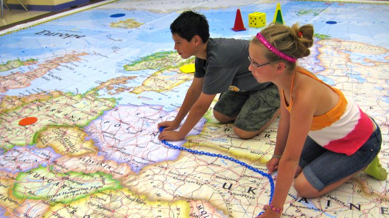
Middle school students spend some time interacting with the National Geographic Giant Map of Europe. The map is touring selected cities across Mississippi. Photo courtesy of Mississippi Geographical Association
Students in 10 cities around the state soon will be able to explore a giant map of Europe, thanks to the Mississippi Geographic Alliance at the University of Mississippi.
The statewide tour, which stretches from Long Beach to Oxford, began Jan. 23 and ends Feb. 24. Measuring 26-by-26-feet, the National Geographic Traveling Map of Europe enables viewers to interact with the world’s second-smallest continent while learning about its rich history and diverse geography.
“The giant traveling map tour is one of our signature programs,” said Carley Lovorn, alliance assistant director. “It’s a fun way to get students, teachers and the public excited about the world around them.”
The vibrant vinyl map will guide students through lessons and fun activities related to Europe’s climate, natural resources, famous landmarks, demographics and more. Activities include a geography-themed version of “Simon Says,” “The Landmark Carousel” and “The Grid Game.”
“The floor maps are an innovative teaching tool to help students learn the content at a deeper level,” Lovorn said. “Physically interacting with the map gives them a unique learning experience that will keep them engaged.”
The map started its tour of Mississippi Jan. 23-25 at Harper McCaughan Elementary School in Long Beach. Other host sites and dates are: Pass Road Elementary in Gulfport, Jan. 26-27; Longleaf Elementary in Hattiesburg, Feb. 1-2; the University of Southern Mississippi, Feb. 3; Cleveland School District, Feb. 8-9; Mississippi Museum of Natural Science in Jackson, Feb. 10-11 and 17-18; Starkville/Oktibbeha Consolidated Schools/Mississippi State University, Feb. 13-16; Isable Elementary in Jackson, Feb. 20-22; and Oxford Elementary School, Feb. 23-24.
National Geographic’s Giant Traveling Maps program was introduced in 2006 with a map of Africa. It has grown to include maps of North America, Asia, South America, Europe and the Pacific Ocean.
“The map of Europe is an important and exciting addition to our ever-expanding roster of giant traveling maps,” said Dan Beaupre, vice president of National Geographic’s Education and Children’s Media group. “We believe this giant map will be an effective tool in enlivening the study of Europe’s geography and history for both students and teachers.”
A member of the nationwide network of state alliances supported by the National Geographic Society, the MGA works to strengthen geographic literacy in the state of Mississippi. The alliance uses workshops, online resources and other programs to help educators prepare students to embrace a diverse world, succeed in the global economy and steward the planet’s resources.
In the 2016-17 academic year, hundreds of thousands of students will interact with these maps. Besides school venues, the maps appear at museums, festivals, fairs and corporate and educational conferences.
The maps reinforce National Geographic’s commitment to increasing geography education through teacher professional development, K-12 curriculum, live events and academic competitions such as the National Geographic Bee.
For more information about the Mississippi Geographical Alliance, visit http://mga.olemiss.edu or contact Lovorn at mclovorn@olemiss.edu or at 662-915-3776. To learn more about the Giant Traveling Maps project, visit http://www.nationalgeographic.com/giantmaps.